


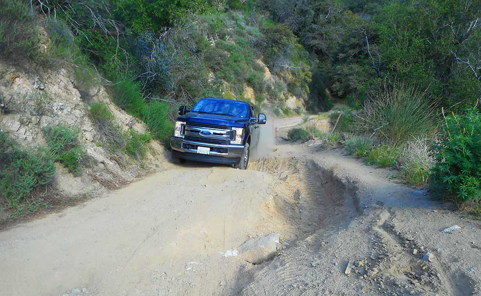
How long before another slice of roadway falls down that 30 ft. drop? (Photo – Reg Green).
The seven-mile dirt road from the Angeles National Forest fire station on Angeles Crest Highway to the top of Mt. Lukens, beloved of hikers and bikers for its solitariness, is now taking such a pounding from vehicles driving along it that it may become impassible.
By Reg Green
The culprit is the antennae that have sprung up on the top of the 5075 ft. mountain to facilitate communication throughout Southern California for everything from emergency services to cell phones and which seem to need continuous maintenance by crews in vehicles ranging from SUVs to heavily-laden trucks and bulldozers.
The result is a collection of massive ruts concentrated in the first part of the road that are up to three feet deep and three feet wide and deepening and widening every day. Within half a mile of the trailhead a slice of the roadway has collapsed down a sheer 30 ft. drop and erosion has undermined so much of the rest that another collapse seems inevitable leaving only a dangerously narrow track in place. At other points these ditches meander across the road so that vehicles have no choice but to cross them, each time displacing another trickle of soil. One monster, 30 ft. long, has to be crossed twice. A water pipe safely buried under inches of earth until a few weeks ago is now on the surface and every vehicle, however heavy, runs over it.
Safety
Even bikers aren’t safe. The edges around some of these depressions are so narrow that a slight misstep can have serious consequences: a biker told me a friend of his had slipped into one of the ruts and broken a collarbone.
The other day, having seen a bulldozer coming back from the 14-mile roundtrip to replace a generator, I followed its distinctive tracks which had relentlessly driven its way through every rut in its way. I know God created bulldozers to do just that and faulty generators have to be replaced but it had displaced more earth in two or three hours than years of natural erosion.
Obviously, if this goes on no maintenance vehicles or fire trucks will be able to get through at all.
The fire road to Mt. Lukens (Photo – Reg Green).
A heroic but futile try
Admittedly, patching up the road poses headaches. A couple of years ago road crews filled in the deepest cuts with earth and gravel, wedged rocks and logs into them and pounded everything down with heavy equipment.
Heartbreakingly, the heavy rains of the winter of 2016-17 washed away almost every trace of the filling, leaving only the rocks and logs in trenches as deep as they were before as a reminder of a heroic but futile try. Sandbags, hauled in and placed so as to divert the streams of water pouring down the hillside, did their job longer but in time were ripped to shreds by passing trucks. The tattered remains can still be seen but their contents have long since been dispersed.
A precious resource
At almost all times of the day this is still a lovely lonely road on the edge of a basin of bulky mountains, heady and high-up, with superb views, including a panorama — only a mile and a half walk from the trailhead — that embraces the entire Los Angeles basin from the Santa Monica mountains, downtown, Long Beach and Catalina Island to the mountains near Palm Springs.
For anyone on foot the vehicles are not a problem. The drivers are friendly and drive cautiously. Within minutes a passing vehicle is swallowed up in this vast wilderness as though it never existed.
But we must handle this precious resource with care. The handful of forest roads are the easiest way for any of us in this area to taste the grandeur of what California was like before the tens of millions of people like you and me arrived and changed most of it out of recognition.
A journalist most of his life, Reg Green lives now in La Cañada Flintridge. He can be reached at his website, NicholasGreen.org.


This Article was mentioned on brid-gy.appspot.com
?
This Article was mentioned on brid-gy.appspot.com
Just walk, end of problem.